Category Archives: Travel

The Old and The New on Congress Avenue

20130602_Congress_Avenue_006

A couple of weekends ago, we had a lot of rain here in Austin. We were all constrained to indoor activities on Friday, Saturday, through Sunday morning, June 2nd, 2013. Nobody complained, as we are always grateful when it rains in Austin, especially in the summer months.

When the rain stopped, and the clouds had parted, I decided to head out and take some photos. I was somewhat tired of the macro photos of the flowers in my neighborhood, so I decided to head to downtown Austin. It was almost 2:00 PM when I parked my CR-V on Willie Nelson Blvd (2nd Street), just east of Congress Avenue.

That put me just south of the construction site of the J. W. Marriot luxury hotel, and 1 block east of The Austonian (seen in the opening photo, which is currently the tallest building in the City of Austin at 56 stories – 683 feet (208 m) tall.

I was travelling light. I brought only my Olympus OM-D E-M5 camera, with the Olympus 12-50mm f/3.5-6.3 lens, and my WhiBal card. No camera bag, no tripod, not even a spare battery. Absentmindedly, I left my hat in the car.

I crossed Congress Avenue to get to the west side of the street and started heading north.

20130602_Congress_Avenue_020

Reminder: You can always view any photo at a larger size by just clicking on it. You will then need to use your browser’s “Back Button” to return to my story.

Now I must mention here that the photo above isn’t really how my camera captured the image. I used the new Upright feature in Lightroom 5’s Develop Module to remove most of the perspective distortion that you get when looking up with a wide angle lens. Not bad for a one-click correction!

20130602_Congress_Avenue_027

I was pleased to see that the overcast sky had pretty much dissipated into the partially cloudy sky.

Here is a photo looking up the side of The Frost Bank Tower, which is 33 stories – 515 feet (157 m) tall.

20130602_Congress_Avenue_028

I always find it interesting how the new architecture and the old architecture co-exist within this relatively small area.

20130602_Congress_Avenue_037

But “old” in Austin, Texas isn’t really very old, as compared to most large cities. Even though Austin is now the 11th most populous city in the United States, it did not even exist before 1839.

20130602_Congress_Avenue_038

Even the iconic Littlefield Building (see with the American flag on top) didn’t start construction until 1910, and was completed in 1912. This 8 story building became the financial center of Austin, and was the height of opulence when it opened.

20130602_Congress_Avenue_042

Here is the out-of-focus One American Center building behind an interesting business sign.

20130602_Congress_Avenue_043

At 6th and Congress, I paused to take this photo looking south.

20130602_Congress_Avenue_059

This is the only other photo that “straightened-up” by using the new Upright feature in Lightroom 5.

I continued heading north until I reached 8th Street, and then I turned around. Between 7th and 8th Streets, the historic Paramount Theatre (1915) sits just to the south (right) of the Stateside Theater (1935).

20130602_Congress_Avenue_061

There isn’t very much traffic in downtown Austin during the middle of a Sunday afternoon.

20130602_Congress_Avenue_065

I crossed over to the west side of Congress Avenue when I got to 7th Street.

At the corner of 6th Street, at the base of the Littlefield building, I had a nice view of the Austonian, 4 blocks to the south.

20130602_Congress_Avenue_076

I was standing at the same corner with this iconic clock.

20130602_Congress_Avenue_077

Looking across the street, I thought that this view of the base of One American Center was interesting enough to spend a minute to capture a few photos of it.

20130602_Congress_Avenue_078

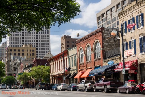
Here’s another one of those “old meets new” images that seem to be everywhere along this stretch of Congress Avenue.

20130602_Congress_Avenue_085

At the entrance to The Frost Bank Tower, I noticed three or four of these large succulent plants.

20130602_Congress_Avenue_088

Now I know that this is not a particularly pretty picture, but I included it just to give you some context for the setting of the next photo, which is part of the same plant, just from the opposite side.

20130602_Congress_Avenue_094

It was getting pretty darn warm, and I had forgotten to bring my hat. I was glad that it was only a 2 block walk back to my car. As I got to the construction site of the new J. W. Marriot hotel, I couldn’t help but look up and take this photo of the three cranes.

20130602_Congress_Avenue_100

Thank you for visiting my blog!

Tour of Circuit of The Americas – Part 2

20130425_Circuit_of_The_Americas_076

This is the second part of my blog posts showing the photos that I took while on a tour of Circuit of The Americas (COTA) race track in Austin, Texas on Thursday, April 25, 2013. Circuit of The Americas was recently constructed just southeast of Austin specifically to be the only Formula One (F1) racetrack in the United States. In case you missed it, you can find the first part here.

Before I get started on Part 2, I need to bring to your attention an inaccuracy that I reported in Part 1. I had stated: “The building on the right is owned by the Formula One organization, and can only be used by the Formula One organization. It therefore sits idle for 51 weeks out of the year. This building is called the paddock.”

A couple of readers pointed out that those statements simply were not true. I sent an email to COTA asking for their help in correcting this information. Here is what they told me: “The paddock building is only used by F1 during that race. It is rented out for events or used as a spectator area during other events. It is not vacant 51 weeks out of the year.”

Now that this has been taken care of, it’s back to Part 2!

I was lucky enough to be allowed to tag along with my wife, Barb, on this tour, which was organized by the UT SAGE group that she belongs to. I brought only my Olympus OM-D E-M5 camera, with the Olympus 12-50mm f/3.5-6.3 lens.

The photo above is the same one that I showed at the end of Part 1 of my story. That is Turn 17 immediately below you in the foreground, and Turn 11 is way off in the distance, near the upper left corner of the photo.

In this blog post, I will not be showing the photos in the order that I took them. Instead, I will try to show the turns of the race track in the order that the racers encounter them.

Turn 1 is in the southeast corner of the tack, and here is what it looks like from the observation tower.

20130425_Circuit_of_The_Americas_095

Reminder: You can always view any photo at a larger size by just clicking on it. You will then need to use your browser’s “Back Button” to return to my story.

The whitish building between the seats and Turn 1 is the parking lot that we were in when I took the photos of Turn 1 (that I showed in Part 1). That is Turn 2 as the track exits the lower left corner of the photo above.

This next photo starts with the pedestrian bridge, located between Turn 2 and Turn 3, and takes you all the way out to Turn 11 in the far back left corner.

20130425_Circuit_of_The_Americas_097

The red, white, and blue painted areas are considered to be “off the official track”. They are more like a “warning track”. The drivers are allowed to drive on them, without any penalty for doing so, if they ended up out there as a result of losing control in the previous turn.

This next photo is basically the same view as the previous one, but I zoom in as far as my little lens will go. It shows Turn 5 (in the foreground) to Turn 11.

20130425_Circuit_of_The_Americas_079

At this point, the racers really get up to some very high speeds as they travel the long straight-away between Turn 11 and Turn 12. That straight away comes into this next photo from the top right corner of the photo.

20130425_Circuit_of_The_Americas_077

Here you see Turns 12 through 16. For a sense of scale, that is a full size water truck on the race track to the left of the pedestrian bridge. That pedestrian bridge is right at the beginning of Turn 17.

Looking straight down from the front of the observation tower (toward the east), you see the short straight-away between Turn 17 and Turn 18.

20130425_Circuit_of_The_Americas_083

Turn 18 is a 90 degree turn to the right, and you can see it in the lower right corner of this photo looking due south.

20130425_Circuit_of_The_Americas_088

When I took the photo above, I was more interested in the multiple horizontal layers: the race track, the back side of the paddock, the grandstand just beyond that, the southern parking lot (and I can see my little CR-V!), the country side view beyond that, and also Texas Toll Road 130 crossing over the horizon.

Looking back down onto the track, here’s a much better view of Turn 18.

20130425_Circuit_of_The_Americas_094

And finally, this next photo completes “our journey” around the track. The stars lead into Turn 19 and the furthest turn from you in this photo is the final turn – Turn 20. Right after that last turn, the racers cross the start/finish line between the paddock and the grand stands.

20130425_Circuit_of_The_Americas_089

So far, I’ve shown you the view from three sides of the observation tower. The fourth side is the back side of the tower, and that is towards the west. At the base of the back side of the tower is the Austin360 Amphitheater.

20130425_Circuit_of_The_Americas_091

The red pipes that swoop up the back side are about 5 feet (1.5 m) from the railing surrounding the platform that we were standing on. To get the previous photo, I leaned over the rail a little bit (certainly not a lot!) and extended my camera out as far as I could while keeping the camera strap around my neck, and used the Live View on the rear LCD to compose the photo.

The schedule of what bands will be performing here is most impressive, and the schedule can be found here. The evening after we were there, The Lumineers were to perform! The next scheduled concert is Jimmy Buffet, who will be there Thursday evening. Dave Matthews Band, Mumford and Sons, and Train are a few of the bands that I personally know that I would enjoy seeing.

You can take the stairs down, and I believe that I was the only one to do so. I knew that it would take the elevator at least two trips to get everyone else in our group back down to ground level. I thought that I would be down before they all got down, but I was mistaken! When I finally got to the ground, the group was nowhere around.

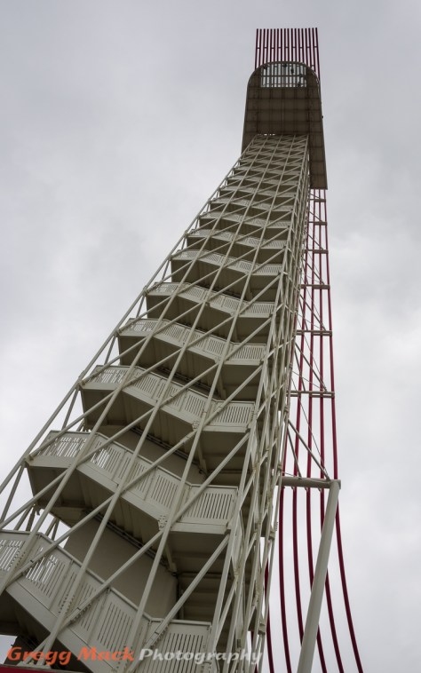
I stood there and took this photo of the is 251 feet (76.5 m) tall observation tower.

20130425_Circuit_of_The_Americas_098

I thought that I heard the faint voice of our tour guide in the distance. He seemed to be in the backstage area of the amphitheater, so that’s where I headed. Just before I caught up with the group, they had all turned around and were heading back towards me…. I had missed the tour guide’s speech, but I swam upstream like a salmon to get only two very quick photos of the amphitheater as seen from the stage.

20130425_Circuit_of_The_Americas_100

Just think – The Lumineers would be on that stage in just over 24 hours, in front of a sold out audience!

I had to walk quickly out of the backstage area to catch up with our tour group. A few others with cameras were standing at the base of the tower looking up, so I figured I had at least a couple minutes to do that myself.

20130425_Circuit_of_The_Americas_105

The photo above is from the back side of the tower, while the next one is from the front side, right by the open door of our bus.

20130425_Circuit_of_The_Americas_109

That was pretty much the end of our tour. The busses took us back to our cars in the south parking lot. The bus drivers, the tour guides, and everyone that we had an encounter with were very friendly, helpful, and answered any question that anyone in our group had.

Barb waited patiently in my “racing Honda” while I got a photo of it in front of the entrance to the grand stands. 😉

20130425_Circuit_of_The_Americas_113

And as we circled our way around to get out of the parking lot, I couldn’t help but stop the car, get out, and take one last parting shot of the entrance with the observation tower also in the photo.

20130425_Circuit_of_The_Americas_115

Well, I hope that you enjoyed seeing what we saw on our tour of Circuit of The Americas (COTA). I wouldn’t call my photos artwork, but I do hope that I did a good enough job documenting what I saw that will give you a good sense of what this new facility looks like. Maybe you will remember seeing my photos when you get out there to see it for yourself.

Thank you for visiting my blog!

Tour of Circuit of The Americas – Part 1

20130425_Circuit_of_The_Americas_004

About a month ago, Barb came home from one of her Monday outings with the UT SAGE group that meets on The University of Texas campus, and said that there was going to be a tour of the new Circuit of The Americas race track. She also said that spouses were welcome, and wanted to know if I was interested. I probably thought about it for, oh maybe 2 seconds, and said “Wow! Hell yes, I’m interested!”. So Barb got us both signed-up, and the tour was this past Thursday, April 25, 2013.

For those who don’t already know, Circuit of The Americas was recently constructed just southeast of Austin specifically to be the only Formula One (F1) racetrack in the United States. They have also had other car and motorcycle races on this track since it held its first F1 race in November 2012. To further use the facility, they also build an outdoor amphitheater for live music performances (named Austin360 Amphitheater).

Now I am like most typical Americans – I don’t know anything about F1 racing, other than there seems to be this huge, wealthy fan base that travels from country to country to watch the qualifying time trials and the actual race on the 3rd day. More than 117,400 people were in attendance to watch the first F1 race on November 18, 2012. The week before the first F1 race at Circuit of The Americas, all 24 racing teams were located in Abu Dhabi – which is 10 time zones away from Austin.

Before you can go on a tour of Circuit of The Americas, you have to know how to get there – and most people in Austin do not know exactly where this facility is. I didn’t really know until the evening before we went.

Map to Circuit of The Americas

The race track is located east of Texas Toll Road 130, about 3 or 4 miles south of Hwy 71. Turn east on FM 812, and go about 1 mile. This is what you will see from the front (south) entrance.

20130425_Circuit_of_The_Americas_001

That red and white structure on the left is an observation tower, and it is a key feature of this facility.

I was travelling light. I brought only my Olympus OM-D E-M5 camera, with the Olympus 12-50mm f/3.5-6.3 lens, and my Whi-Bal card. No camera bag, no tripod, no spare battery, and not even a hat.  The description of the tour that Barb had indicated that we would be driven around on busses. Also, everything would be outside. I didn’t think that I would need any fast prime lenses for that, and I was really hoping that we would at least be able to get off the bus occasionally to get some decent photos.

After eating lunch with several of the SAGE members at the round Hilton Hotel at the Austin Bergstrom airport, we arrived at the Circuit of The Americas (COTA) facility at 12:30 PM. It was overcast, and was supposed to remain that way. I did a custom white balance on my Olympus camera and then put my WhiBal card away.

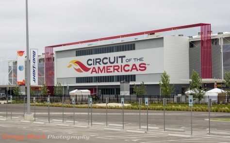
We had about 15 minutes to kill before we were to get on the little busses, so we mingled with the other SAGE members and I took a few photos from the parking lot, and that is when I took the photo at the beginning of this post.

20130425_Circuit_of_The_Americas_013

One of the other SAGE members, Dave, took this photo of Barb and I.

20130425_Circuit_of_The_Americas_009

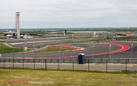
This is the only portion of the race track that can be seen from the main parking lot at the south entrance. This is the hill that leads up to Turn 1, and the seats for the spectators that want watch this exciting portion of the track.

Here’s a map of the race track itself

Map of Circuit of The Americas

The start/finish line is where the “A” pin is located.

Here is what the start/finish area looks like from near Turn 1.

20130425_Circuit_of_The_Americas_038

Reminder: You can always view any photo at a larger size by just clicking on it. You will then need to use your browser’s “Back Button” to return to my story.

I’d like to point out a few things in that photo. You can see downtown Austin in the upper right corner. The bridge in the center, near the horizon, is on Texas Toll Road 130. The spectators sit in the grandstands on the left.

The building on the right is owned by the Formula One organization, and can only be used by the Formula One organization. It therefore sits idle for 51 weeks out of the year. This building is called the paddock.

(Edited on May 1, 2013. A couple of readers pointed out that those statements simply were not true. I sent an email to COTA asking for their help in correcting this information. Here is what they told me: “The paddock building is only used by F1 during that race. It is rented out for events or used as a spectator area during other events. It is not vacant 51 weeks out of the year.”)

The F1 racers start from a stationary start, and you can see the white markings on the pavement for where each car is to be positioned. They immediately race up a rather steep hill towards where we were standing, and when they get to the top of the hill they have to make a hard left hairpin turn. This is what our view of Turn 1 looked like.

20130425_Circuit_of_The_Americas_020

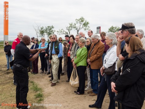
There seemed to be about 50 or more people on this UT SAGE tour, and this photo shows about a third of them listening to one of our tour guides as we stood there overlooking Turn 1.

20130425_Circuit_of_The_Americas_028

The tour guides told us that it cost $500,000,000 (half a Billion dollars) to build this race track, and that it was entirely paid for by individual investors. One of the SAGE members brought up that the government (city, county, or state ?) was paying $25 Million a year for the F1 membership, though. People get all worked up over that, and I don’t really understand why. Supposedly Austin gets that $25 Million back by having this track here (tourists, lodging, meals, worldwide exposure, etc.). I don’t know if that’s true or not, and I don’t really care, and this is not a political blog… so back to seeing my photos of this spectacular race track.

There is a large “overrun area” on the outside of this hairpin turn. I don’t know how many multi-million dollar race cars ended up running out into that area….

20130425_Circuit_of_The_Americas_049

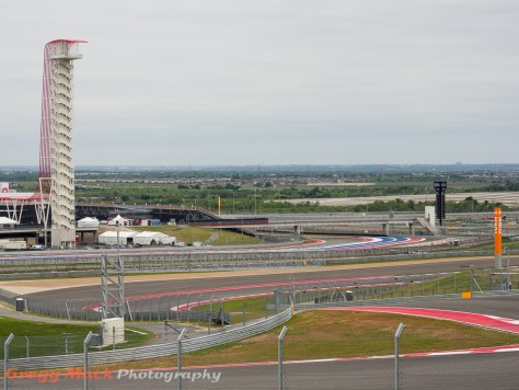
This is the view when looking beyond Turn 1 over towards Turn 2, with a better view of the observation tower.

20130425_Circuit_of_The_Americas_035

The red “pipes” sweep up the back and over the top of the observation tower, where they form a ceiling over the white platform that people get to stand on.

We then got back onto our 4 little busses and drove to the far northeastern edge of the race track, where Turn 11 is located. Here is the track as it approaches Turn 11.

20130425_Circuit_of_The_Americas_054

And here is Turn 11. It’s one heck of a hairpin curve!

20130425_Circuit_of_The_Americas_055

Here we are blocking your view of this incredible turn. When the tour guide asked how fast we thought that the cars were going as they made their way around this turn, I was thinking “40 mph, 50 tops” (64 kph, 80 tops).

20130425_Circuit_of_The_Americas_058

I wasn’t even close! The average speed that they slow to is “just” 69 mph (111 kph). That must really be something to see!

Between Turn 11 and Turn 12, the cars supposedly get up to over 200 mph (322 kph). Turn 12 is just before the stands that you see off in the distance. The rate of acceleration and then braking must really be incredible.

20130425_Circuit_of_The_Americas_071

OK so after 10 minutes or so at Turn 11, it’s back to the busses.

20130425_Circuit_of_The_Americas_068

We drive over to the middle of Turn 17, and park the busses right at the base of the observation tower.

20130425_Circuit_of_The_Americas_073

This observation tower is 251 feet (76.5 m) tall. The elevator has only two stops: ground floor and floor 25!

I have too many photos to show you to cram them all into one huge, slow loading blog post, so I’m going to stop this one right here. I have 15 more photos set aside for Part 2 of this tour (9 from up on the tower).

I will end Part 1 of this story by showing you just one photo from up top. This is the very first photo that I took when I got to look out from that observation tower.

20130425_Circuit_of_The_Americas_076

That is Turn 17 in the foreground, and Turn 11 is way off in the distance, near the upper left corner of the photo.

In Part 2, I will not be showing the race track in the order that I took the photos. Instead, I will try to show the turns in the order that the racers encounter them. I hope that you will return in a couple of days to see them, as I am pretty excited about what I have to show you.

Edited June 7, 2013: You can find Part 2 by clicking here.

Thank you for visiting my blog!

A Short Walk on East 6th Street

This post is really the tail end of my previous post. Sunday, April 7, 2013, was an overcast day, but I was tired of being in the house. I decided to go somewhere that I seldom go – downtown Austin. I ended up walking south on Congress Avenue from the Texas State Capitol down to 2nd Street, where I turned around and headed back north – until I got to 6th Street.

I was travelling light. I brought only my Olympus OM-D E-M5 camera, with the Olympus 12-50mm f/3.5-6.3 lens, and my X-Rite ColorChecker Passport. No camera bag, no tripod, not even a spare battery or a hat.

The truth is, I was just trying to get back to where I parked my car, which was three blocks east of Congress Avenue, on Trinity Street between and East 8th and East 9th Streets. I thought that 6th Street might be a “more scenic” route than 7th or 8th Street.

Within the first block after turning east on 6th Street, on the north side of the street sits the very historic Driskill Hotel, which has very recently been purchased by the Hyatt

20130407_Downtown_Austin_080

I had my lens zoomed to as wide as it would go, which was 12mm (24mm equivalent), and even then I couldn’t get the entire front of the hotel into the frame. This is the only photo that I took that day where I wish I had some different equipment with me. My Canon 5D Mark II with the 24mm Tilt-Shift lens would have allowed me to capture the same photo – and not have the hotel seeming to be falling backwards (due to the perspective distortion). On the other hand, this would have been the ONLY photo that I would have wanted to be lugging that Canon camera (and a bag with at least one extra lens). Instead, this is “as good as I could do, with what I had with me”…

At the very first corner, which is Brazos Street, this is the view looking northeast along East 6th Street. Most Austinites do not see this scene at 4:00 PM on a Sunday afternoon. Actually most Austinites never see this scene, as East 6th Street is a one-way street, with traffic coming straight towards you in this next photo.

20130407_Downtown_Austin_083

Reminder: You can always view any photo at a larger size by just clicking on it. You will then need to use your browser’s “Back Button” to return to my story.

I really don’t have much more of a story to tell. I only walked 2 more blocks along the south side of East 6th Street before I turned north on Trinity Street to get back to my car. Even though I don’t have much of a verbal story to tell, I did capture several photos within those 2 blocks that I would like to share with you!

People from all over the country (the world?) that come to visit Austin and ask “What’s there to do in this town?” are told about East 6th Street as one of the first suggestions. Obviously then, there are several businesses that cater to those who are visiting Austin.

20130407_Downtown_Austin_085

Everyone who lives in Austin has heard or seen the slogan “Keep Austin Weird”. Most find it amusing, but nobody finds it offensive. This web site claims to be the origin of this slogan. I don’t really care, I just liked the tie-dyed T-shirt one vendor had hanging outside their front door.

20130407_Downtown_Austin_086

And while you’re out partying on 6th Street, maybe you’ll have your thought processed altered enough that you might think that this is a good idea. 🙂

20130407_Downtown_Austin_087

But really, the reason people come to East 6th Street is to drink and to listen to live music. I’ve never been to the Chuggin’ Monkey, but I like their sign….

20130407_Downtown_Austin_088

After crossing San Jacinto Blvd, here’s another view looking northeast toward Trinity Street. Note that there really are not any modern buildings on East 6th Street, like there were back on Congress Avenue.

20130407_Downtown_Austin_091

On the southeast corner of East 6th Street and Trinity Street sits Maggie Mae’s. I always thought that it was named after an old (but great) Rod Stewart song called Maggie May, but evidently the real story behind the name of this bar can be found here.

20130407_Downtown_Austin_093

This little blackboard sign was in front of Maggie Mae’s, and I thought it was funny enough to photograph it.

20130407_Downtown_Austin_095

OK, now that I was at Trinity Street, I needed to head north for two blocks to get back to my car. While still standing right outside of Maggie Mae’s, I looked back to the west, towards Congress Avenue, where you can see the modern buildings along Congress Avenue towering over the older buildings along East 6th Street.

20130407_Downtown_Austin_098

Look closer at the photo above, and see if you can see the pair of cowboy boots dangling above the street…

It was just a quick, rather uneventful 2 block walk back to my trusty Honda CR-V.

20130407_Downtown_Austin_101

Even though I had only been walking for 1 hour and 20 minutes, the time had just flown by, and I was certainly glad that I had left the house, despite the overcast and dreary sky that had been so prevalent earlier in the day.

It just goes to show you that sometimes you just need to get out there, and make the best of what you can of it.

Thank you for visiting my blog!

Walk on Congress Avenue

Last Sunday, April 7, 2013, was an overcast day, but I was tired of being in the house. I needed to get out and walk around with my camera. I needed to go somewhere where a gray sky wouldn’t affect me and my photography too negatively. I decided to go somewhere that I seldom go – downtown Austin. During my 25 minute drive to get downtown, I noticed that the overcast sky was beginning to break up into a partly cloudy sky.

I was travelling light. I brought only my Olympus OM-D E-M5 camera, with the Olympus 12-50mm f/3.5-6.3 lens, and my X-Rite ColorChecker Passport. No camera bag, no tripod, not even a spare battery or a hat.

I drove up and down Congress Avenue, and even at 2:45 PM on a Sunday afternoon, there are no parking spaces available. I ended up parking three blocks east of Congress Avenue, on Trinity Street between and East 8th and East 9th Streets.

I thought that I would head towards the Texas State Capitol Building, which is located at 11th and Congress. As I walked west on East 10th Street, just west of San Jacinto Blvd., I noticed this building with reflections of both a Catholic Church and the Texas State Capitol building.

20130407_Downtown_Austin_006

At the corner of Brazos St. and East 10th, I just looked up at the Texas Department of Transportation building and took this simple photo.

20130407_Downtown_Austin_011

Reminder: You can always view any photo at a larger size by just clicking on it. You will then need to use your browser’s “Back Button” to return to my story.

I was pleased to see that the overcast sky had pretty much dissipated into the partially cloudy sky.

This next photo was taken while standing in the center of the crosswalk on Congress Avenue at 10th St.

20130407_Downtown_Austin_019

I really didn’t have a plan, other than to just walk south on Congress all the way to 1st or 2nd Street and then come back up Congress Avenue on the other side of the road.

20130407_Downtown_Austin_021

There are many, many building along Congress Avenue that have been designated as historical landmarks. It makes for a very interesting mixture of old buildings and modern buildings.

20130407_Downtown_Austin_022

Just south of 7th Street, on the west side of Congress Avenue is this interesting statue of Angelina Eberly.

20130407_Downtown_Austin_033

The plaque at the base of this statue tells this fascinating story: “In 1842 Texas was an independent nation, and Austin was its capital. Sam Houston, the president of the Republic of Texas, regarded Austin as a vulnerable and unsuitable location for the seat of the government and waged an unsuccessful campaign to have it moved to his namesake city (Houston). As a last resort, the President sent a military detachment to Austin to remove the government archives. When an innkeeper named Angelina Eberly discovered the men loading their wagons, she rushed to the corner of what is now Sixth and Congress and fired the town cannon, blowing a hole in the Land Office building and rousing the populace. The citizens chased down Houston’s men, recovered the archives, and gave them to Mrs. Eberly for safekeeping. This statue honors a bold woman whose vigilance and short temper preserved Austin as the capital of Texas. It was presented to the citizens of Austin on September 26, 2004, by Capital Area Statues, Inc.”

20130407_Downtown_Austin_036

There’s no doubt where I took this next photo from. 🙂

20130407_Downtown_Austin_041

I’ve seen Kirk Tuck show this same photo on his blog before, so I thought I’d just put my blatant copy here on my blog….

20130407_Downtown_Austin_043

Looking southeast, one sees the Frost Bank Tower, which is located between 4th and 5th Streets, on the east side of Congress Avenue.

20130407_Downtown_Austin_045

At 422 Congress Avenue is Shiner’s Saloon. I’ve never been there, but I like their sign our front!

20130407_Downtown_Austin_050

We are now down to 3rd Street.

20130407_Downtown_Austin_052

Just north of 2nd Street sits The Austonian, which is a residential building. A t 683 feet (208 m) tall with 56 floors, this is the tallest building in Austin.

20130407_Downtown_Austin_054

At the base of the Austonian, is the little coffee shop Caffé Medici.

20130407_Downtown_Austin_056

I thought that I would get myself a cup of coffee and do stake out a place for some relaxed people watching, but as I poked my head inside, I was surprised at how small, and crowded this place was. I guess it must be very good, because there were at least 15 people in line there to get coffee at 3:30 PM on a Sunday afternoon. Someday I’d like to give it a try, though.

So I crossed Congress at 2nd Street, and took a few photos of one of the Austin GuitarTown guitars, named Twinkle Twinkle Lonestar.

20130407_Downtown_Austin_058

Back in 2007, there were 32 of these guitars scattered around Austin for public display before being auctioned off to help a charity. Dad and I located all of them, and photographed them wherever they happened to be located. You can see them all here. It’s hard to believe that was 6 years ago…

Just north of 2nd Street, there is huge construction site, with three very large cranes. This is future site of the 1000 room J.W. Marriot Hotel.

As I passed that construction site, here’s an interesting view of both old and new buildings in downtown Austin.

20130407_Downtown_Austin_064

Out front of the Frost Bank Tower, sits one of my favorite Austin GuitarTown guitars, named Vibrancy. I guess just like colorful things, and this one uses it very creatively!

20130407_Downtown_Austin_074

A couple blocks north, I turned east on the semi-famous East 6th Street. The photos that I took there will be the subject of my next blog post.

So, the day started out being what I considered pretty crappy for going out and making photographs, but it certainly didn’t turn out that way. It just goes to show you that sometimes you just need to get out there, and make the best of what you’re dealt.

Thank you for visiting my blog!